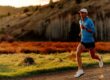
When most people think of the trails in Georgia, elevation is not the first thing that comes to mind. And while the mountains may not stand as tall as in the west, this list of the hardest hikes in Georgia will give even the best athletes the challenge they are looking for. I’ve had a chance to run all of these and can tell you each presents it’s own unique experience. Often using these as training runs for trips to Colorado and back west. And some of the toughest ultra races in the South East are run on these trails.
Some highlights from below include hiking Georgia’s highest peak, Georgia’s highest waterfall, and the official starting point of the Appalachian Trail.
Key Takeaways
- Georgia offers challenging hikes that serve as training grounds for Western trips and host tough Southeastern ultra races.
- Notable hikes include Mt. Yonah Trail with epic cliff views, the Coosa Back Country Loop in Vogel State Park, the Appalachian Approach Trail starting at Amicalola Falls, the Arkaquah Trail to Georgia’s highest point, and the grueling Duncan Ridge Trail known for its steep grades and roots.
- These hikes provide various challenges, from elevation gains to rugged terrains, appealing to experienced hikers and trail runners.
A List of The Hardest Hikes in Georgia
Mt Yonah Trail
Distance: 4.5 Miles
Type: Out & Back
Elevation Gain: 1,466ft
All Trails Link / Map: All Trails Link Click Here
I’ve had a few people email me this one as a write in. And I must admit, Mt Yonah trail is a great introduction to the hardest hikes in Georgia. Located just outside of Cleveland, GA, Mt Yonah is an incredibly popular out & back leading to some epic cliff views. Some of the best in GA.
Once you get to the top of the mountain some of the best views are located just off trail. But pretty easy to find. And on the weekend you can just follow where others are going/coming from. I recommend getting there either early or later in the afternoon. As it can get very busy in peak hours and the parking lot can fill up.
The Coosa Back Country Loop
Distance: 12.8 Miles
Type: Loop
Elevation Gain: 3,628ft
All Trails Link / Map: All Trails Link Click Here
If you have never visited Northern GA’s Vogul State Park then you are in for a treat. Located only a few minutes outside of Blairsville GA, the park will greet you with a small lake surrounded by several of the state’s tallest peaks. While most people visiting the park will climb Blood Mountain, the tallest of the park’s peaks. The Coosa Back Country Loop will avoid the crowds and take you up both Coosa Bald and Slaughter Mountain. The loop can be done either way but starting counter clockwise is considered the tougher of the two choices. You also have the option to add in Blood Mountain for a little extra sauce if you are in the mood.
There is typically plenty of parking in Vogul State Park. You will need a state park pass or can pay for a day use permit on site but will need cash.
The Appalachian Approach Trail
Distance: 17.9 Miles
Type: Out & Back
Elevation Gain: 4,160ft
All Trails Link / Map: All Trails Link Click Here
If you only have time for trail while in Georgia then the Appalachian Approach Trail is a great choice. Starting at Amicalola Falls State park, this is the starting or ending point for everyone completing the famed Appalachian Trail (AT). You will start your hike with Georgia’s highest waterfall and the 604 steps leading up to the top Amicalola falls. From there the trail is pretty straight forward taking you to the top of Springer Mountain and the official starting point of the AT. Here you have to get a photo with the plaque of the most famous trail in the world. And while the trail offers respectable elevation gain and mileage with 17.9 miles. The real challenge of this trail is the miles of roots, rocks and holes it will feel like a whole lot more 17.
There is parking available at the park but it fills up quickly on popular days and you will need to pay. There is also a lodge at the top of the falls you can drive up to.
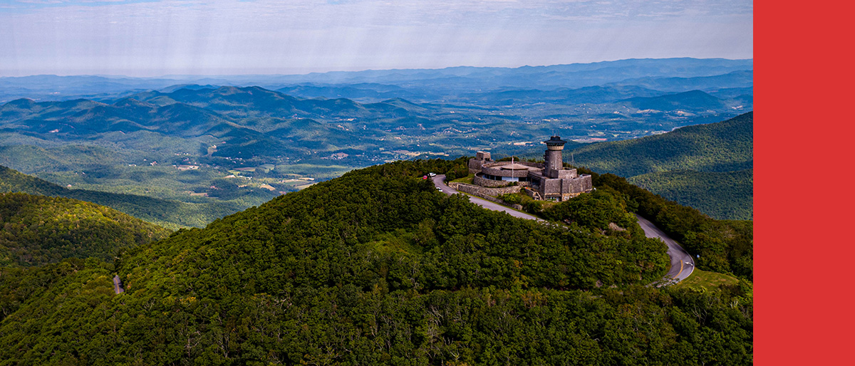
The Arkaquah Trail
Distance: 11.3 Miles
Type: Out & Back
Elevation Gain: 3,713ft
All Trails Link / Map: All Trails Link Click Here
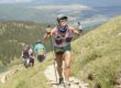
The Arkaquah trail is an 11 mile out and back trail leading you to the highest point in Georgia, Brasstown Bald. The trail will connect you to the parking lot at the top of the mountain where you will follow a paved path an extra .6 miles to the lookout tower at the top. It’s worth the hike! And while most people will end up driving the paved road up the lookout tower at the top of the peak, the Arkaquah Trail is known as the “hard way up”. The trail starts with one of the toughest climbs in the state gaining 1,400ft of gain in less than 2 miles. You will then follow the ridge line all the way to Brasstown Bald.
The ridge line offers some great views when the leaves are down in the fall, winter & early spring making those the best time to go. Summer will over peek-a-boo views but the hike is still worth it. And the observation tower is a great little halfway point stop.
Parking is small and limited at the trailhead. So get there early as the location has been getting more popular. That said this is not a heavily trafficked trail compared to others in the area.
The Duncan Ridge Trail
Distance: 17.6 Miles
Type: Point to Point
Elevation Gain: 6,587ft
All Trails Link / Map: All Trails Link Click Here
The Duncan Ridge Trail is the unquestioned king of the hardest hikes in Georgia. With 6,500+ft of gain in 17 miles, grades reaching 30% and a trail that mostly consists of rocks and roots. This trail can challenge even the most seasoned runners and hikers. It has become well known in the ultra running world, hosting the Georgia Death Race and the Duncan Ridge 50k (10,000+ft Gain). Two of the hardest races for their distances in the south east.
There are a couple important things to note about this trail. The east ending point of this trail is just shy of the top of Coosa Bald, connecting to the Coosa Back Country Trail (listed above). So if you are doing this as a point to point you will have to add some distance to your hike out. Although it will mostly be downhill.
There is very limited parking at the trailhead. Other options include connecting via the Benton Mackaye trail via the Skeenah gap trail head. This adds some quick elevation!
Conclusion
In summary, Georgia presents a range of challenging hikes ideal for experienced hikers and trail runners. Notable trails like Mt. Yonah, Coosa Back Country Loop, Appalachian Approach Trail, Arkaquah Trail, and Duncan Ridge Trail offer diverse terrains and elevations, making them excellent training grounds for Western trips and hosting tough Southeastern ultra races. These hikes provide stunning views and unique experiences, catering to adventurers seeking a real challenge in Georgia.
If you have any trails you feel are worthy of being one of the hardest hikes in Georgia let me know in the comments below!
Also check out: