When looking for mountains in the south east most people think of the trails in North Carolina. And for good reason. The list of the hardest hikes in North Carolina will give any athlete a run for their money. Proving why these rocky and rooty trails have earned the nickname, the Beast Coast. I’ve had a chance to run all of these, but not of all as they are laid out in some of the combo routes below. That said, knowing the routes I can promise these will not let you down in views and difficulty.
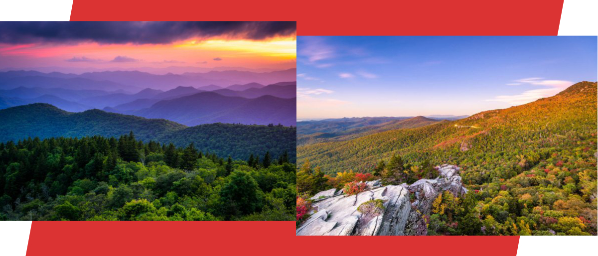
Highlights from the trails include hiking the two highest peaks on the East Coast. A trail with ladders leading to the country’s highest walking suspension bridge. And a trail with 2,900ft of gain in 2.25 miles.
Key Takeaways
- North Carolina boasts challenging hiking trails often referred to as the “Beast Coast” due to their rugged nature.
- Notable highlights include hiking the East Coast’s two highest peaks and trails featuring ladders and cables for added adventure.
- The hardest hikes in North Carolina include Mount Mitchell Trail with a challenging uphill climb, the Shining Creek-Old Butt Knob Loop Trail offering rough terrain, and Colbert Ridge Trail known for being less crowded.
- Additional challenging trails comprise the Colbert Ridge to Mount Mitchell to Maple Camp Ridge Loop (Counter Clockwise) and Grandfather Mountain via Profile Trail with ladders and a steep ascent.
- The Celo Knob via Black Mountain Crest Trail offers a memorable climb, while the Green Mountain Trail features significant elevation gain early in the hike.
- The Black Mountain Crest Trail is a ridgeline trail tagging multiple peaks, including the East Coast’s two highest, while the Woody Ridge Trail is renowned as the most difficult trail in North Carolina due to its steep and intense elevation gain.
A List of The Hardest Hikes in North Carolina
Mount Mitchell Trail
Distance: 11.9 Miles
Type: Out & Back
Elevation Gain: 3,694ft
All Trails Link / Map: All Trails Link Click Here
You had to know that the tallest peak on the east would have to make the list. The Mount Mitchell Trail is a popular but challenging hike that leaves a lot of newcomers feeling unprepared. The out and back leaves you with a long 6 miles of straight uphill to start. And just as much downhill on the way back. Which tends to eat you more than the uphill. The only downside to this hike is that there is a road almost to the top of Mt. Mitchell. And a man made viewing platform at the top. So while you will have been working hard to earn the view. You can expect large crowds of people wearing crocs and flip flops at the summit.
Shining Creek-Old Butt Knob Loop Trail
Distance: 8.3 Miles
Type: Loop
Elevation Gain: 2,890ft
All Trails Link / Map: All Trails Link Click Here
Credit: Paul L.
Located in the Shinning Rock Wilderness. This loop offers hikers and runners difficult trail in the form of vert, rough terrain, and sections of heavy overgrowth. All signs of a great trail that doesn’t get a lot of traffic. Taking you to the top of Shining Rock (6,001ft), you will also summit Dog Loser Knob and Old Butt Knob. You are in for some great views and even a small waterfall.
Colbert Ridge Trail
Distance: 7.7 Miles
Type: Out & Back
Elevation Gain: 2,965ft
All Trails Link / Map: All Trails Link Click Here
The Colbert Ridge Trail is a lesser known trail in the area so if you are looking to get away from people. This one may be the perfect choice for you. You will also find this trail used on a couple other combo routes on this list. That’s because it’s a beast of a way to get up to the ridge line and connect with the Black Mountain Crest Trail. Featuring just under 3,000 feet of gain in under 4 miles. The Colbert Ridge Trail is probably only second to the Woody Ridge Trail (see below) in difficulty.
Colbert Ridge to Mount Mitchell to Maple Camp Ridge Loop (Counter Clockwise)
Distance: 18.1 Miles
Type: Loop
Elevation Gain: 5,144
All Trails Link / Map: All Trails Link Click Here
You are going to see a lot of out & backs and point to points on this list, so I wanted to make sure we had a good loop on the list. Incorporating the parts of the two previous trails on our list. You know this is going to be a spicy loop. While both ways are considered challenging, going counterclockwise is considered the harder of the two routes.
Grandfather Mountain via Profile Trail
Distance: 11.3 Miles
Type: Out & Back
Elevation Gain: 4,035
All Trails Link / Map: All Trails Link Click Here
One of my favorite hikes in North Carolina, this one doesn’t have an official AllTrails but combines a few popular trails to provide a more unique way of seeing one the area’s more popular Mountain Summits, Grandfather Peak. What makes this trail truly unique for the area in the ladders, cables, and rock climbing needed to make the pass. Nothing too technical, But it does add some fun to the trip. But what makes this hike truly challenging is the climb up Profile Trail. Starting out flat with some decent in the first mile, it packs almost all the elevation gain into a short 2 mile burst. So be ready!
It’s recommended that you do this one on a weekday or as early as possible. As the summit of Grandfather Peak can get crowded. It has a road leading almost to the top and the country’s highest walking suspension bridge. Making a popular tourist destination.
Celo Knob via Black Mountain Crest Trail
Distance: 13.9 Miles
Type: Out & Back
Elevation Gain: 4,612ft
All Trails Link / Map: All Trails Link Click Here
Another combo featuring the Colbert RIdge Trail. The climb to Celo Knob is one you will definitely remember. You will be treated to 3,300 feet of gain in the first 4 miles of trail. Then riding the ridge to the top of Celo Knob. This is the kind of trail that never gives your legs a rest. And the downhill may even eat you more than the ups.
Green Mountain Trail
Distance: 10.1 Miles
Type: Out & Back
Elevation Gain: 3,864ft
All Trails Link / Map: All Trails Link Click Here
Credit: Paul L.
Located in the Middle Prong Wilderness, the Green Mountain Trail takes you to the top of Green Knob. And while 3,800+ ft of gain over 10 miles would be tough enough. The truth is that you get most of that in the first 3.5-4 miles. And the trail starts climbing from the beginning so get ready to climb!
Black Mountain Crest Trail
Distance: 11.3 Miles
Type: Point to Point
Elevation Gain: 5,147ft
All Trails Link / Map: All Trails Link Click Here
The crown jewel of the Black Mountains. The Black Mountain Crest Trail takes you up and along a beautiful ridgeline tagging multiple peaks, including the two highest on the east coast. Mt. Mitchell (6,684 ft) and Mt. Craig (6,647 ft). The trail is labeled as a point to point since it is possible to park near the top of Mt. Mitchell. But a lot people will treat this as an out & back, working their way back down the ridge. Making it 22+ miles total. Make sure you check ahead for water and weather conditions before taking on this trail.
Woody Ridge Trail
Distance: 4.5 Miles
Type: Out & Back
Elevation Gain: 2,913ft
All Trails Link / Map: All Trails Link Click Here
There are longer trails and there are trails with more elevation. But mile for mile the Woody Ridge Trail is the unquestioned “most difficult” trail in North Carolina. The trail is a 4.5 out & back. Which means you are essentially getting 2,900 feet of gain in less than 2.25 miles. That’s well over 1,000ft per mile of gain. And poles are not going to help you with this one. You will need your hands free to grab trees and roots as you make the massive climb up to meet with the Black Mountain Crest Trail.
Conclusion
North Carolina boasts some of the East Coast’s most challenging and rugged hiking trails, earning them the moniker “Beast Coast.” Notable highlights include ascending the two highest peaks on the East Coast and encountering unique features like ladders, cables, and steep ascents. The list of the hardest hikes in North Carolina offers a range of options, from the grueling Mount Mitchell Trail to the lesser-known Colbert Ridge Trail. Hikers seeking a longer and more demanding adventure can explore the Colbert Ridge to Mount Mitchell to Maple Camp Ridge Loop (Counterclockwise).
Grandfather Mountain via Profile Trail stands out as a favorite with its combination of ladders, cables, and rock climbing, coupled with a challenging ascent. Celo Knob via Black Mountain Crest Trail and the Green Mountain Trail provide memorable climbs, while the Black Mountain Crest Trail is a ridgeline adventure tagging multiple peaks, including the two highest on the East Coast. For those up to the ultimate challenge, the Woody Ridge Trail is renowned as the most difficult trail in North Carolina due to its steep ascent. These trails offer a diverse range of experiences for seasoned hikers, promising breathtaking views and relentless difficulty on the “Beast Coast.”
If you have any trails that you think I missed, and you feel are worthy of being one of the hardest hikes in North Carolina. Let me know in the comments below!
And check out: