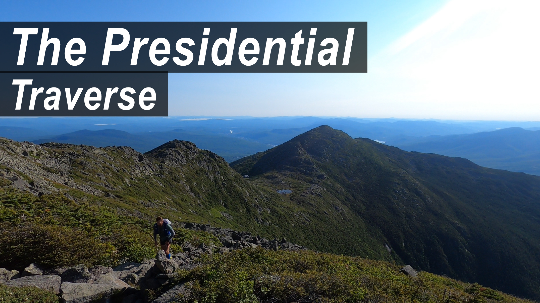
If you’re an avid hiker or backpacker, then you’ve no doubt heard of the Presidential Traverse. The most famous trail in the North East United States, is also one of the most well known in the country. And for good reason. It is the only trail on the east coast that allows you to hike / run above the treeline. Taking you over 20 miles and 9,000+ feet of gain while summiting eight of the presidential peaks. Making this is a bucket list challenge for many people. And of those seeking an even bigger adventure, some people challenge themselves to complete the Presidential Traverse in One Day, either hiking or running.
And if you are one of those people, then this post is for you. Below I’ll cover all of the info you need to knock out this one of a kind hike in less than a day. So let’s get to it!
- Trail Overview
- Presidential Peaks
- Weather Info
- Water Info
- Wildlife Info
- Shuttle Info
- Gear List
- Where to Stay
- Video – Completing the The Presidential Traverse in One Day
The Presidential Traverse in One Day – Hiking & Trail Running Info
The Presidential Traverse Overview
What makes the Presidential Traverse such a well known trail? For most people, they will assume it is the expansive views from above the treeline. Something you can’t find anywhere else on the east coast. But the incredible feeling of being able to see for miles in every direction is only dwarfed by the absolute brutality of the trail itself. The highest peak on the travers, Mount Washington is affectionately known by locals as the “rock pile”. And that’s exactly what this trail is. A pile of boulders that goes for miles and miles. Often the only sign of the trail in front of you are the cairns that dot the hillside, perched on top of random boulders along the path. It’s this steep and technical trail that makes this such a challenge. One that many people have on their bucket list.
AllTrails Link: Click Here – Note that the trail is longer and has more vert than listed on AllTrails.
The Route – Which Way to Go
The traverse itself is a point to point trail that can be done either north to south, or south to north. Most people doing the Presidential Traverse in one day will do it from north to south.
North to South – Starting at Valley Way / Appalachia Trailhead
The main reason for this being that you get the biggest climb out of the way first. Some 4,000+ feet up to Mount Madison (and the Madison Shelter). This also saves you an absolutely miserable downhill at the end of your day. The second reason is that the Madison Shelter is located at around mile 4. Where you can get fresh water. This means you don’t have to weigh yourself down with water to start your hike. Just enough to make it up the climb to the shelter. And the third reason this is the more popular route is that it ends at a more populated location. Close to a travel center and hotel. A perfect place to park your car and catch a shuttle (more info below) or hitch a ride to the trailhead for Madison Shelter.
South to North – Starting at Webster-Jackson Trailhead
You can also go south to north. But all of what is said below will be opposite. You’ll spend almost your whole day climbing higher and higher with the toughest part of the trail at the end. The first water stop once you make a ridge is much further so you will need to carry more from the start. And you will end in a much less populated area making it harder to coordinate your ride. The shuttles leave from the south. And while they can pick you up at the northern trail head. This requires timing your hike well to avoid waiting or missing your shuttle.
Permits: There are no permits are required to hike or camp in the park.
Car Camping: Sleeping in your vehicle in the parking lot the night before is not allowed Click Here for more info.
Presidential Peaks (North to South):
- Mount Madison – 5,367 ft
- Mounts QA & Mount Adams – 5,774 ft
- Mount Jefferson – 5,712 ft
- Mount Washington – 6,289 ft
- Mount Monroe – 5,371 ft
- Mount Pierce – 4,311 ft
- Mount Jackson – 4,052 ft
- Mount Webster – 3,911 ft
The Presidential Traverse Weather Info
I can not say this enough, make sure you check the weather before attempting any hike in White Mountain National Forest. The area is known for extreme weather changes and people are rescued off these mountains regularly. With the most common reasons being weather and fatigue. Mount Washington, the tallest peak on the trail, has recorded winds over 100mph and rain, snow, and sleet is known to blow in without notice. So again, CHECK THE WEATHER BEFORE YOU GO.
All that said, to help you plan your trip so you can increase your odds for good weather. Below are some infographics about the average weather conditions on the trail.
* The below stats are taken from Weather-USA.com and are taken from Mount Washington, the highest point on the trail.
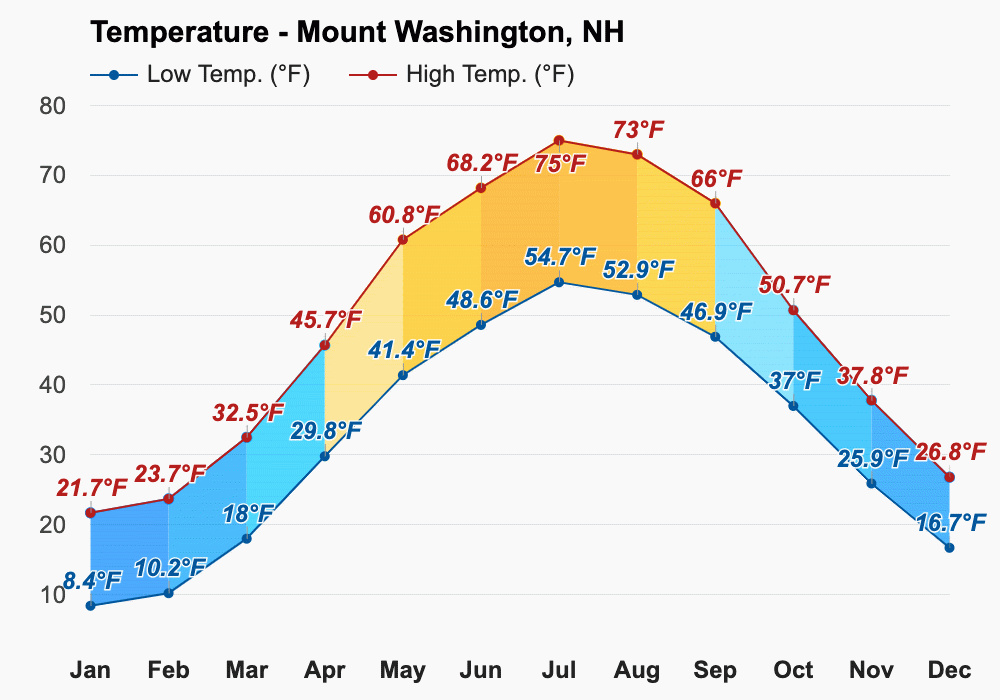
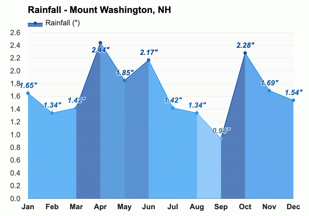
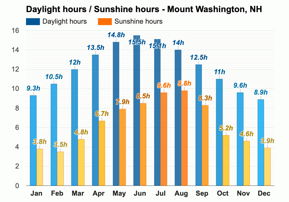
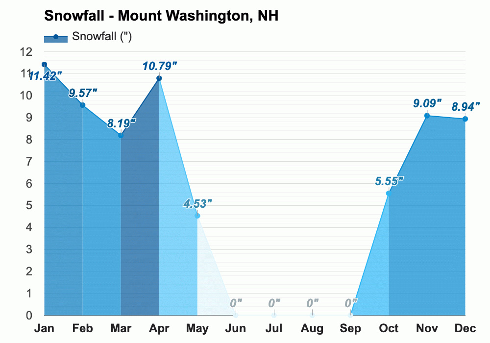
To get up the minute weather and live weather cams at the National Parks Service official site click here.
The Presidential Traverse Water Source Info
Being above the treeline for most of the trail means having access to water becomes that much more important. And along the Presidential Traverse there are typically four main water stops. From north to south:
The Madison Hut – Located at the base of Mount Madison
Mount Washington Visitor Center – Located at the top of Mount Washington.
Lake of the Clouds Hut – Located between Mount Washington and Mount Monroe.
Mizpah Spring Hut – Located between Mount Pierce and Mount Jackson
White Mountain National Forest Wildlife Info
Some of the wildlife you might see in the White Mountain National Forest include moose, black bear, white-tailed deer, coyote, balg eagle, peregrine falcon, bobcat, fox, mink, porcupine, beaver, and raccoon. Bear spray in not required or necessary.
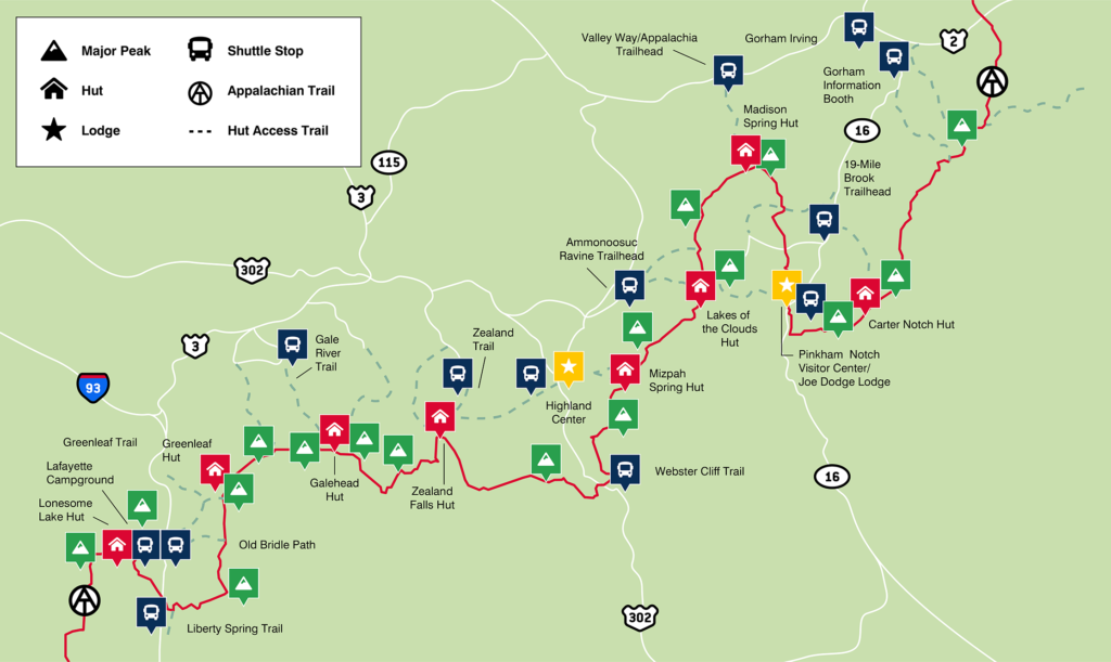
Presidential Traverse Shuttle
The most popular shuttle service is run by the Appalachian Mountain Club. Below you can find all of the info, link, price, dates, and phone number for the service.
AMC White Mountains Hiker Shuttle
Phone: (603) 466-2727
Link: https://www.outdoors.org/shuttle/
Flat Rate Cost:
Member: $20/Per Person/One-Way Trip
Non-Member: $24/Per Person/One-Way Trip
Reservations: Not required but strongly recommended
Dates if Operation:
Daily: 6/2/22 – 9/18/22
Weekends & Holidays Only: 9/24/22 -10/16/22
Shuttle Map:
Presidential Traverse in One Day – Gear List
Here is the complete list of the gear I’m planning on bringing with me on our trip. I’ll work on going more in depth on another post. But if you have these items you will just need to worry about fuel.
Note: This doesn’t include fuel/nutrition/food, I’ll cover that below.
My Complete Gear List
- Trail Running Shoes – The more cushion the better. This trail is rough.
- Running Socks – Do not wear cotton socks.
- Mirco Spikes – Just in case the trail is frozen over or covered in snow. Make sure to check the weather.
- Gators – Keep rocks out of your shoes.
- Underwear (sometimes built into your shorts) – Brand you trust and have trained in.
- Shorts – Something you trust and have trained in.
- Shirt – Something you trust and have trained in.
- Hat – You are going to be above the tree line.
- Windbreaker
- Water Proof Jacket
- Emergency Poncho
- Emergency Blanket
- Sunglasses – Polarized.
- UV Sleeves (optional) – Great to start the day and cover yourself if you start to burn.
- Warm Weather: Running Vest/Bag & Cold Weather: Running Vest/SCRAM
- 4 Water Bottles – I Like soft flasks.
- Water Filter – This one is the easiest and fastest.
- Hiking Poles (optional) – You’re going to want something light and fully collapsible.
- Body Lube – Very important!
- Sunscreen – Protect your skin.
- Wet Wipes – For emergencies on the trail.
- 1 Small Roll Athletic Tape – For quick fixes on the fly.
- Phone/Camera – Make sure to take photos.
- 2 Plastic Bags – 1 for your camera and 1 for your money/wallet.
- Headlamp – You may be starting or ending (or both) in the dark.
- Extra Set of Batteries – Amazon Makes Batteries for a great price!
- Watch – Even if you’re not tracking your run. You should know what time it is and have some way to gauge your pace. There is good chance your phone will run out of battery.
Where to Stay:
If you are going north to south, I recommend staying in Gorham, New Hampshire. A small town located only 15 minutes from the Appalachia Trailhead. If you’re starting in the South or taking a morning shuttle up north, the closest place to stay is the AMC Highland Center at Crawford Notch. Which is walking distance from the Jackson-Webster Trailhead.
Video: The Presidential Traverse in One Day – Hiking & Trail Running
Conclusion
The Presidential Traverse is an iconic hiking and trail running challenge in the North East United States. This remarkable trail offers breathtaking views above the treeline, taking you over 20 miles and 9,000+ feet of elevation gain while summiting eight presidential peaks. Completing the Presidential Traverse in One Day is a bucket list achievement for many outdoor enthusiasts.
In this blog post, we have provided a comprehensive overview of the trail, including the route options, information about the presidential peaks, essential weather considerations, water sources, wildlife insights, and details about shuttle services. Additionally, we’ve shared a helpful gear list for those embarking on this adventure and highlighted recommended places to stay in the area.
Whether you’re a seasoned hiker or a trail runner seeking a remarkable challenge, the Presidential Traverse offers an unforgettable experience in the White Mountain National Forest. Remember to plan carefully, check the weather, and be prepared for the rugged terrain. With the right preparation and determination, you can conquer this incredible journey and create lasting memories.