With a mix of mountains and lush green woods, it’s no wonder that West Virginia has become a known destination for outdoor activities. And as you can imagine, the state has plenty of tough trails to call its own. Below we’ll go over the hardest hikes in West Virginia. Taking you through wet creeks, thick forest, and white rock mountains. There is something for everyone on the list. So check it out and let me know if you feel I’ve left any worthy trails off the list.
Key Takeaways
- West Virginia offers challenging hikes with woods, wildlife, overlooks, and more.
- Pond Run and White Rocks Loop Trail, deep in George Washington National Forest – Lee District, is an 11.2-mile trail featuring streams, mountains, and multiple lookouts.
- Rocky Ridge Trail, near Caldwell, West Virginia, is a 4.9-mile out-and-back trail with a steep ascent and peek-a-boo views.
- Kanawha Trace, just outside Ona, is a 30.5-mile point-to-point trail popular for backpacking, known for caves, rock formations, and wildlife.
- Halfmoon Mountain via Bucktail Trail Loop, near Baker, is a 10.2-mile loop with challenging climbs and rewarding views.
- Perry Valley Loop Trail, in George Washington National Forest – Lee District, is a 29.5-mile loop offering wildlife, rock outcroppings, and cliffside views.
- North Fork Mountain Trail: Out-and-Back from WV-28, located in Monongahela National Forest, is a 14.4-mile out-and-back trail with expansive ridge views.
- North Fork Mountain Trail to Chimney Top, in the Potomac Wildlife Management Area, is a 5.3-mile out-and-back trail with wildflowers, rock formations, and stunning views.
A List of The Hardest Hikes in West Virginia
Pond Run and White Rocks Loop Trail
Distance: 11.2 miles
Elevation Gain: 2,247ft
Type: Loop
AllTrails Link: All Trails Link Click Here
Features: Woods, wildlife, fire tower, overlooks, and plenty of views.
Description: A great intro to a tougher hiking experience. The Pond Run and White Rocks Loop trailhead is located deep in the George Washington National Forest – Lee District. Leading you across multiple streams and featuring just enough mountain to make you work for it. There are several good lookouts including a quick stop off at the White Rocks Overlook. Most people have this trail at a little over 12 miles. So don’t get mad when you hit 11 miles and still have a ways to go.
Rocky Ridge Trail
Distance: 4.9 miles
Elevation Gain: 1,500ft
Type: Out & back
AllTrails Link: Click Here
Features: Woods, wildlife, old structures, and peek-a-boo views.
Description: Located in the Greenbrier State Forest just outside of Caldwell, West Virginia. This trail may not offer a huge payoff, but it does give you a good workout on your way up. You will get almost all of the 1,500+ft of gain in just under 2 miles at the beginning of the trail then leveling off before connecting to the County ROute 60/34 road. There are some peek-a-boo views at the top but in the lusher months it can be hard to see anything.
Kanawha Trace
Distance: 30.5 miles
Elevation Gain: 4,347ft
Type: Point to Point
AllTrails Link: All Trails Link Click Here
Features: Wild flowers, wildlife, old cabins, rock formations, caves, waterfalls, and creek crossings.
Description: Located just outside of Ona, West Virginia the Kanawha Trace is a 30.5 mile point to point trail. Popular for backpacking trips the trail is mostly used for multi day trips. But at just under 50k in distance with around 4,500ft of gain, the Kanawha Trace has gained in popularity with trail runners and endurance hikers. The trail itself features some great caves and rock overhangs and is known for its old abandoned cabin and wildlife.
Halfmoon Mountain via Bucktail Trail Loop
Distance: 10.2 Miles
Elevation Gain: 2,030 ft
Type: Loop
AllTrails Link: All Trails Link Click Here
Features: Remote, wildlife, creek crossings, rock formations, and lookout views.
Description: A reasonably popular weekend hike, the Halfmoon Mountain via Bucktail Trail Loop is located in the George Washington National Forest – Lee District near Baker, West Virginia. At just over 10 miles, the loop features a few campsites but makes for a great day hike. The climbs are tough but nothing too crazy. And you will be rewarded with some great views from the top.
Perry Valley Loop Trail
Distance: 29.5 Miles
Elevation Gain: 5,206ft
Type: Loop
AllTrails Link: All Trails Link Click Here
Features: Wildlife, rock formations, wood bridge, and expansive views.
Description: Located in the George Washington National Forest – Lee District, the Perry Valley Loop Trail is just under 30 miles and just over 5,000ft of gain. FOr me this is the classic West Virginia loop. You’re going to get wildlife and woods. Then be treated to incredible rock outcroppings and some stunning cliffside views. And while most people will break this up into multiple days. It makes for a great long day hike or trail run.
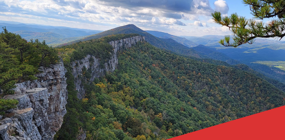
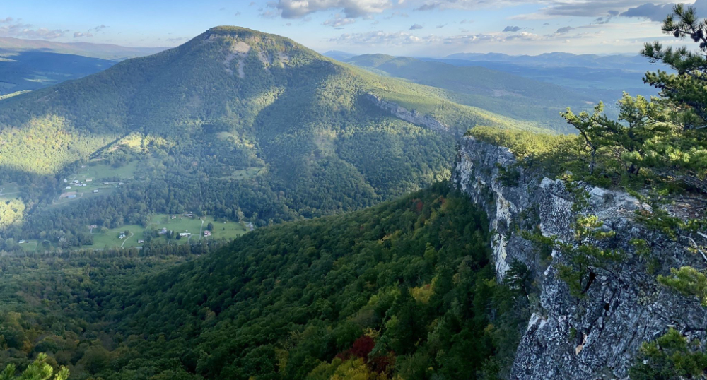
North Fork Mountain Trail: Out-and-Back from WV-28
Distance: 14.4 Miles
Elevation Gain: 3,625ft
Type: Out & Back
AllTrails Link: All Trails Link Click Here
Features: Wildlife, forest, ridge travers, rock formations, and lots of expensive views.
Description: Located in the Monongahela National Forest, the North Fork Mountain Trail: from WV-28 travers the spine of the mountain. Rewarding hikers and runners with incredible views of the rocky ridge protruding from the lush mountains. Chimney Rock is also just a short out and back on this route, and a worthwhile addition to the trip.
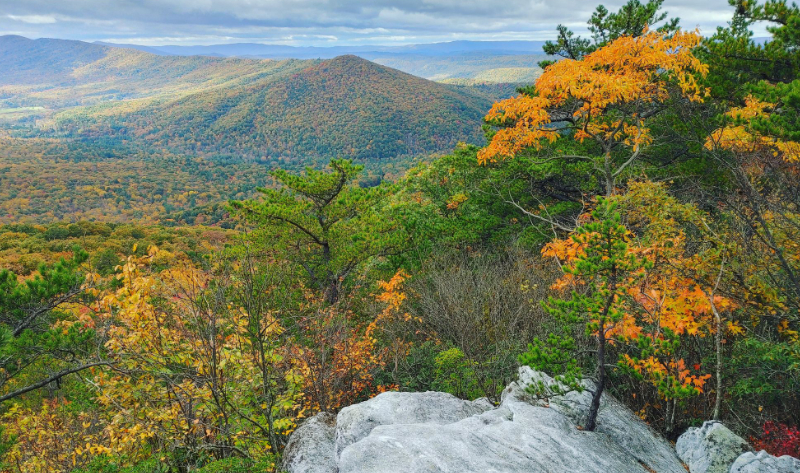
North Fork Mountain Trail to Chimney Top
Distance: 5.3 Miles
Elevation Gain: 1,971ft
Type: Out & back
AllTrails Link: All Trails Link Click Here
Features: Wild flowers, woods, rock formations, and expansive views.
Description: Located in the Potomac Wildlife Management Area, the North Fork Mountain Trail to Chimney Top is a 5.3 mile out and back featuring just under 2,000ft of elevation gain. The trail is rated as difficult and is considered a popular & challenging day hike suitable for year around use. Those making the climb will be rewarded with stunning rock outcrops and incredible views of the cliffs and valley below.
Check out some of the other toughest trials in other states below!