Want to challenge yourself with one of the hardest hikes in Nevada? Then the list below has you covered. With trails up to 18 miles, featuring class 3 and 4 climbs, and more. You will be treated views, Nevada’s highest point, waterfalls and more. If adventure is what you’re looking for. You will not be disappointed.
The list features trails from all over the state. If there is a trail you think should make the list, let us know in the comments below.
Key Takeaways
- Nevada offers some of the toughest hikes, featuring class 3 and 4 climbs, and stunning views.
- The list includes challenging trails from all over the state.
- Turtlehead Peak Trail near Blue Diamond offers rugged climbs with incredible views of Vegas, Spring Mountain Ranch, and Calico Basin.
- Frenchman Mountain Trail towers over Las Vegas, providing epic views of the city and Lake Mead, making it a popular hike for locals.
- Gray Cap Chute to Chute Trail near Las Vegas includes waterfalls and advanced class 3-4 scrambling, recommended for experienced hikers.
- Kraft Peak to Big Bird Peak Travers west of Las Vegas is a class 3/4 route with technical sections, offering challenging scrambles.
- Boundary Peak, Nevada’s highest point, features a remote trailhead and navigation challenges, with stunning views from the summit.
- Mount Jefferson Trail is a remote loop outside of Round Mountain, offering beautiful and secluded terrain with several scrambles.
- The Arc Dome Trail near Round Mountain offers amazing basin views on the way to the summit and manageable length for most hikers.
- The Leviathan Cave Trail near Hiko starts with switchbacks, steep inclines, and small sections to scramble, leading to remote cave views.
- Scorpion Mountain and Black Hill, located outside of Henderson, is a brutal hill climb with a ridge trail, navigation challenges, and stunning elevation gain.
A List of The Hardest Hikes in Nevada
Turtlehead Peak Trail
Length: 4.6 Miles
Elevation gain: 1,988ft
Type: Out & Back
AllTrails Link: AllTrails Link Click Here
Description:
Located near Blue Diamond, Nevada, Turtlehead Peak Trail is a rugged climb that features a few scrambles to the top. But the views are 100% worth the work on this one. With incredible views of Vegas, the Strip, Spring Mountain Ranch, and Calico Basin. This one will have you enjoying the scenery all the way up and down the mountain. Just make sure to be on the lookout for carnes. Route finding is part of the adventure on this one. And it’s only recommended for the experienced hiker/trail runner.
Reports are that as of 10/2021 you need a reservation to enter the park. Go to recreation.gov.
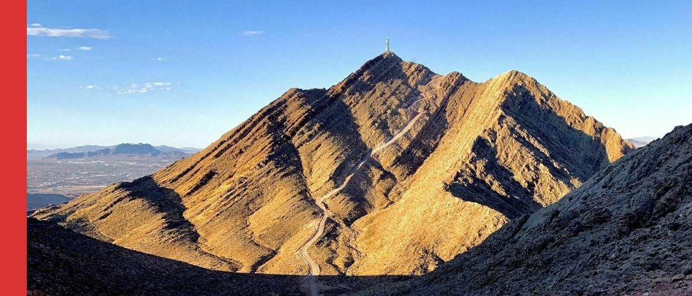
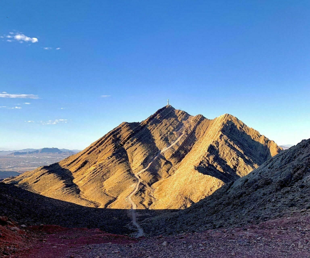
Frenchman Mountain Trail
Length: 4.4 Miles
Elevation gain: 2,139 ft
Type: Out & Back
AllTrails Link: AllTrails Link Click Here
Description:
Towering over the east of Las Vegas is Frenchman Mountain. And to the top, a jeep trail leading to several radio towers. Along with some epic views of the entire city and of lake mead. The Frenchman Mountain Trail is one of the hardest hikes in Nevada along with being a popular route for locals to hike and run because it’s so close to the city. And it is even a popular night destination for hiking. For amazing views of the city lights. And with over 2,000ft of gain in less than 2.5 miles, get ready for a burner!
Gray Cap Chute to Chute Trail
Length: 5.8 Miles
Elevation gain: 2,240 ft
Type: Loop (More a lollipop without and back at the end)
AllTrails Link: AllTrails Link Click Here
Description:
Located near Las Vegas, the Gray Cap Chute to Chute trail features a waterfall and advanced class 3-4 scrambling. This harder climbing is located near the top. Because of this the trail is only recommended for experienced adventurers. For those that do want to take on the challenge. The Gray Cap Chute to Chute will offer a rewarding challenge and amazing views at the top. Just be careful!
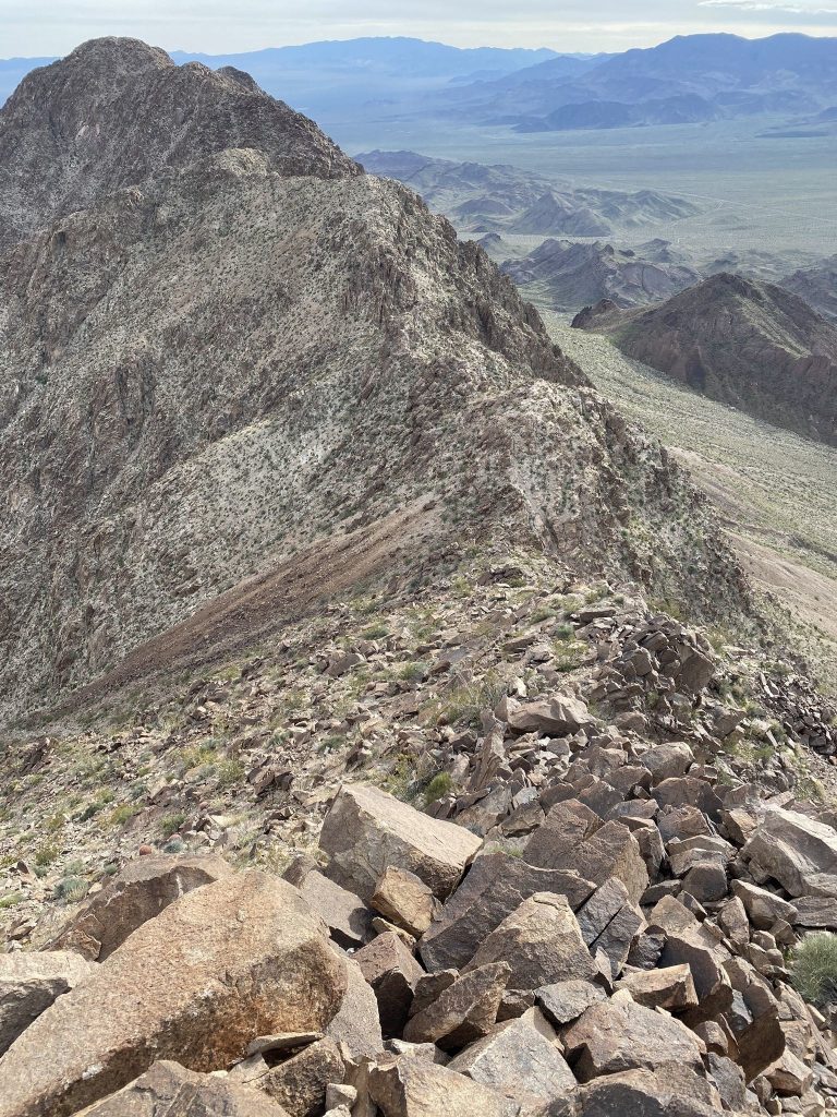
Kraft Peak to Big Bird Peak Travers
Length: 2.9 Miles
Elevation gain: 1,113ft
Type: Loop
AllTrails Link: AllTrails Link Click Here
Description:
Located just west of Las Vegas, the Kraft Peak to Big Bird Peak Travers is a class 3 / 4 hiking route. So while It’s not long. The trail more than makes up for the distance with vert and technical sections. Both clockwise and counter clockwise feature scrambling. So the route is up to you. There are a lot of trails running through this area as well. I always recommend this but here it’s extra helpful to make sure you have the map downloaded.
Reports are that as of 10/2021 you need a reservation to enter the park. Go to recreation.gov.
Boundary Peak
Length: 7 Miles
Elevation gain: 4,215 ft
Type: Out & Back
AllTrail Link: AllTrails Link Click Here
Description:
Just within the western state line, Boundary Peak is Nevada’s highest point. And one of the hardest hikes in Nevada. The trail itself is 7 miles and features just over 4,000 feet of gain. But the real challenges include getting there. The trailhead for this peak is incredibly remote. Even by Nevada standards. And then staying on trail. Having some navigation skills will help with this one. And make sure to follow the carens. And if you do make it up, enjoy tagging the state’s highest point. One most can’t say they have done.
Mount Jefferson Trail
Length: 18 Miles
Elevation gain: 6,128ft
Type: Loop
AllTrails Link: AllTrails Link Click Here
Description:
Mount Jefferson Trail is a remote loop located outside of Round Nevada. It’s considered to be a local bucket list hike because of how beautiful and secluded the trail is. With several scrambles it makes for an adventure no matter if you’re doing it in one day or 3. The loop with an added out and back features a long steady climb no matter which way you choose to go. And during the winter months snow is common on the trails at higher elevations. There are also a lot of creek crossings along this trail, 10+ in total. And keep your eyes out for flocks of bighorn sheep along the trail
The Arc Dome Trail
Length: 12.7 Miles
Elevation gain: 4,596 ft
Type: Out & Back
AllTrails Link: AllTrails Link Click Here
Description:
With amazing basin views on the way up. The Arc Dome Trail offers stunning high plains travers leading to an amazing view at the top. If you’re looking for something that’s a little longer. But still manageable in one day for most people. Then this may be the hike for you. And being located near Round Mountain in central Nevada, it’s drivable for most of the state. There are 30+ switch backs on the way up. So give yourself a little extra time for this one. And make sure to pack food, water, and layers.
The Leviathan Cave Trail
Length: 3.8 Miles
Elevation gain: 2,198ft
Type: Lollipop
AllTrails Link: AllTrails Link Click Here
Description:
The Leviathan Cave Trail is located in the Worthington Mts. Wilderness near Hiko, Nevada. Starting with a series of switchbacks you will eventually encounter some steep inclines. And small sections to scramble. This trail is very remote but the views at the top are worth every step. From the summit the trail to the cave is not well marked. And I won’t give any hints on how to get there. If you’re interested please contact your local chapter of the National Speleological Association. A rappel or short belay is needed to get into the cave. Meaning if you get down you may not be able to get out without the right gear. Be very careful.
Scorpion Mountain and Black Hill
Length: 2.4 Miles
Elevation gain: 1,500ft
Type: Out & Back
AllTrails Link: AllTrails Link Click Here
Scorpion Mountain and Black Hill is a brutal hill climb outside of Henderson Nevada. The trail follows the ridge up Black hill to just over 4,000ft. And with 1,500 of elevation and navigation you will be sure to get your fill. It should also be noted that the trailhead for this climb doesn’t start at a parking lot. So there will be an added distance of a minimum of 1.5 miles. And make sure to download a map beforehand. There are literally 50+ trailers in the area so it can be hard to navigate.