Consistently rated as one of the toughest trails on the east coast. The Black Mountain Crest Trail is the highest trail east on the east coast, tags the most 6,000ft peaks on the east coast, and culminates at Mount Mitchell. Which at 6,684ft, is the highest point east of the Mississippi River. And at just over 11 miles point to point, with almost 6,000ft of elevation gain, it’s no wonder that this trial has earned the nickname, “the Beast of the East.”
Having just had the opportunity to run (hike and climb) this trail, I thought it would be a great idea to leave some tips and trail info for those looking to tackle this monster. So let’s get to it, with our Black Mountain Crest Trail – Hiking & Trail Running Tips.
Key Takeaways for Black Mountain Crest Trail Hike:
- Toughest trail on the east coast, with 6,000ft+ peaks and culminating at Mount Mitchell, the highest point east of the Mississippi River.
- 11.5 miles point-to-point with 5,800ft+ elevation gain.
- Rocky, lush ridge trail with steep ascents, descents, ropes, and technical sections.
- Limited water sources; plan accordingly.
- Trailhead access and parking tips provided.
- Expect slower return on an out-and-back hike due to technical terrain.
The Black Mountain Crest Trail – Hiking & Trail Running Tips
Length: 11.5 Miles
Type: Point to Point
Elevation Gain: 5,800ft+ (AllTrails is wrong)
AllTrails Link: All Trails Link Click Here
Location: Burnsville, North Carolina (40 Minutes outside of Asheville)
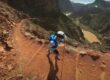
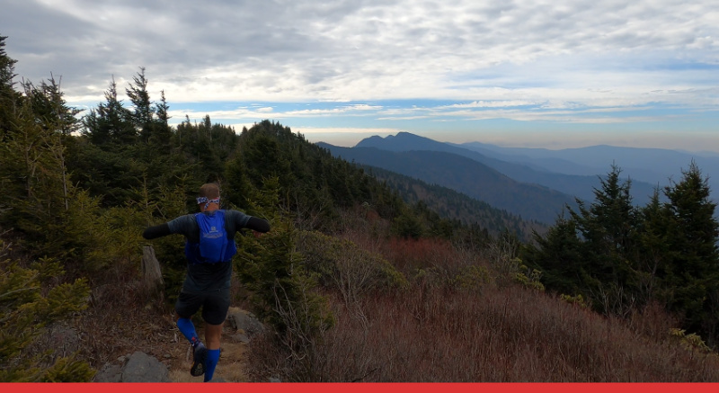
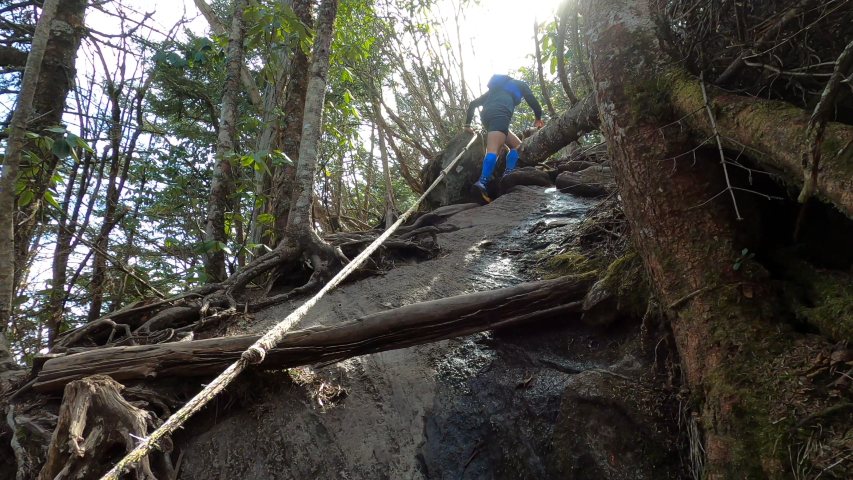
Description: Starting at Bowlens Creek Road in Burnsville North Carolina. The Black Mountain Crest Trail starts with 3-4 miles and 3,000+ feet of gain leading you to the crest of the Black Mountains. Then following the ridge line for another 7+ miles to Mt Mitchell. The ridge itself is rocky and lush, full of trees and roots. You can expect long and steep ascents and descents as you tag the 6,000ft peaks that litter the trail. Some sections feature ropes to assist. While others will have you doing 1-2ft step ups. As you attack grades that will have you using your hands to grab the rocks and roots in front of you.
Water: There is water at mile 3.5 and at Mt Mitchell (turned off seasonally). There is no water on the ridge.
About The Black Mountain Crest Trail
Accessing the Black Mountain Crest Trailhead on Water Shed Rd, just off Bowens Creek Road, requires navigating a few essential details. While Water Shed Road is private, it is permissible to turn onto it. Limited parking, approximately three spots, is available on the right shortly past the first house, although these spots can become quite muddy. To reach the trailhead, continue along the paved road to the right of the house with the green roof, and the trail becomes visible after a short 100-yard trek. Additional parking can be found beyond the paved road, also on the right side of the house with the green roof.
The initial stretch of the trail involves a demanding 3.5-4 mile uphill climb, gaining over 3,000 feet in elevation. Water is accessible around mile 3.5 but becomes scarce until reaching Mt. Mitchell. It’s crucial to note that the water at Mt. Mitchell is turned off seasonally, so checking ahead is advisable. Beyond this point, the trail presents a series of steep ascents and descents, with some sections featuring ropes for assistance. The ridge itself is exceptionally technical, marked by large rocks, roots, and substantial step-ups. As a point-to-point trail, those planning an out-and-back should be prepared for a slower return journey, primarily due to the challenging technical terrain along the ridge, which includes both uphill and downhill sections.
Trail Tips & Info
- The Black Mountain Crest Trail head is located on Water Shed Rd, just off of Bowens Creek Road. Water Shed Road is private, but it is ok to turn onto.
- After you turn onto Water Shed Rd there will be parking (roughly 3 spots) located on the right just passed the first house on the right. These spots can get very muddy.
- To get to the trail from here, just continue on the paved road to the right of the fenced house with the green roof. The trail will become clear in a 100 yards or so.
- There does appear to be more parking located past the paved road located to the right of the house with the green roof. This will lead you to the small foot bridge leading across Bowens Creek and to the trail.
- The first 3.5-4 miles of the trail are uphill. Gaining 3,000+ feet.
- There will be water around mile 3.5. This will be the last water until you reach Mt Mitchell.
- Mt Mitchell’s water is turned off seasonally. So make sure to check before you go.
- Once you make the ridge the trail features a series of very steep ups and downs. With some sections providing a rope to help up and down.
- The trail on the ridge is incredibly technical. With lots of big steps, roods and large rocks.
- The Black Mountain Crest Trail is a point to point. If you are looking to do this as an out and back, be prepared to go slower on the way back. While containing a large amount of descent. Along the ridge the technical up hills and downhills will slow you down.
Conclusion
The Black Mountain Crest Trail stands as a formidable challenge on the east coast, offering hikers and trail runners an exhilarating adventure. With its rugged terrain, steep ascents, and breathtaking views, it’s a trail that demands preparation and respect. Remember to plan for limited water sources, follow the provided trailhead access tips, and brace yourself for a slower return on an out-and-back journey. Taming “the Beast of the East” is no small feat, but the rewards of conquering this high-altitude adventure are boundless. So, gear up, take on the challenge, and savor the incredible experience of the Black Mountain Crest Trail. Happy hiking and trail running!