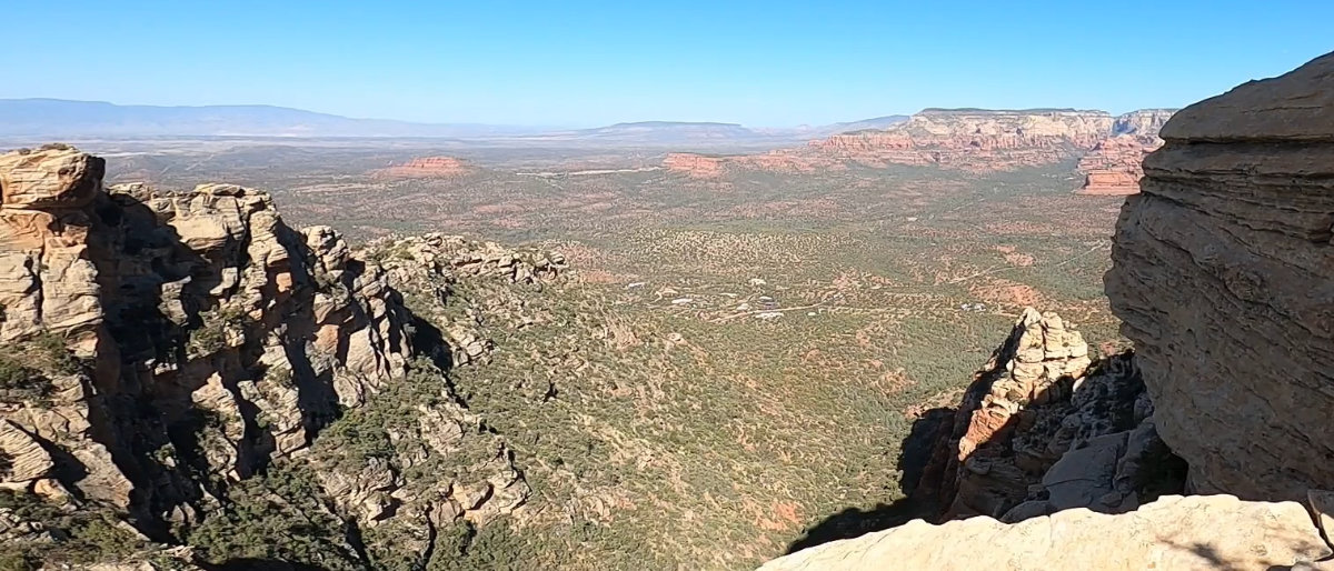
Just minutes from town, avoid the crowds and challenge yourself to the most difficult hike in Sedona. Featuring class 3 scrambles and 360 degree views that don’t stop from start to finish, Hiking Capitol Butte in Sedona, Arizona offers you the chance to stand on top of the city.
Key Takeaways:
- Hiking Capitol Butte in Sedona, Arizona offers a challenging class 3 scramble with stunning 360-degree city views.
- Consider arriving early or using an alternate trailhead to avoid parking congestion.
- Bring a minimum of 2 liters of water per person as there’s no water source on the route.
- Route finding is easier on the way up; pay close attention on the way down.
- Prepare for a class 3 scramble, dress appropriately, and be cautious in case of storms.
Hiking Capitol Butte in Sedona, Arizona
Trail Info
Length: 2.8 Miles
Type: Out & Back
Elevation Gain: 1,700ft+
AllTrails Link: All Trails Link Click Here
Description: The hardest hike in Sedona Arizona. Featuring amazing views directly overlooking the city Sedona. The trail features some class 2 route finding and some short sections of class 3 scrambles.
For those seeking to conquer the iconic Capitol Butte trail in Sedona, some strategic considerations can enhance your experience. Arriving early or exploring the less-crowded Lizard Head trailhead is advisable, as the traditional starting point is shared with the immensely popular Devil’s Bridge trail, often leading to lengthy wait times during peak seasons. With no water sources along the route, packing at least 2 liters of water per person is a must. The ascent is relatively straightforward, marked by cairns, but the descent can be trickier; vigilance is needed to avoid wandering off-course. This journey entails a Class 3 scramble, so prepare to use your hands and dress appropriately. Finally, keep a close eye on the weather, as storms can pose a threat, necessitating a quick descent or finding shelter to evade lightning and swift water flow on the slick rock terrain.
Hiking Capitol Butte Tips & Info
- Get there early or think about using the alternate trailhead. The traditional Capitol Butte route shares a parking lot with Devil’s Bridge, one of the most popular trails in Sedona. A Instagram hot spot, lines can be in the hours during peak season which overflows the parking. Think about using the Lizard Head trail head as an alternative. You can see that route by clicking here.
- There is no water on this route, so plan accordingly. It took us 3 hours moving at a comfortable pace. But both of us are in very good shape. Taking into account a possible emergency, I’d bring a minimum of 2 liters of water per person.
- Route finding on the way up is pretty easy. Follow the carnes and look for the easiest way and that’s probably it. On the other hand, route finding on the way down is a bit harder. Make sure you are paying attention, it can be easy to follow a water run that looks like a trail and get off course.
- This is a class 3 scramble. So plan on using your hands and getting a little dirty. Make sure you plan your shoes and clothes accordingly.
- If you see a storm coming, get off the butte. And if you can make it down, at least get off the peak, staying close to the ground and getting under a rock overhang. Lightning and fast running water on slick rock are a risk.
Conclusion
Hiking Capitol Butte in Sedona, Arizona promises an exhilarating adventure with its challenging class 3 scramble and breathtaking panoramic views of the city. While the journey offers thrills, remember to plan ahead to beat the crowds, bring ample water, and stay vigilant about route finding. This trek is not for the faint of heart, but the reward of standing atop the butte is an unforgettable experience in one of Arizona’s most scenic destinations.
FAQs
What is Capitol Butte, and where is it located?
Capitol Butte is a prominent red rock formation in Sedona, Arizona. It’s part of the Sedona Red Rock Country, located just west of the city of Sedona.
Is a permit required to hike Capitol Butte?
No, you do not need a permit to hike Capitol Butte. It’s on public land, and access is free.
What is the difficulty level of the hike?
The hike can be quite challenging, depending on your chosen route. The difficulty varies, but it generally involves steep and rocky terrain. Some sections can be considered strenuous.
How long is the hike to the summit of Capitol Butte?
The length of the hike can vary depending on your chosen route, but the summit hike can be anywhere from 3 to 6 miles roundtrip.
What is the best time to hike Capitol Butte?
The best time to hike is in the cooler months, typically from fall through spring. Summers can be extremely hot, and the rock can become scorching. Early morning and late afternoon hikes are recommended to avoid the heat.
Are there any dangerous sections on the trail?
Yes, there are some exposed sections and areas with steep drop-offs. You should be cautious and use proper hiking equipment if you plan to explore these parts. Some routes also require technical climbing skills.
What are the most popular trails to hike Capitol Butte?
The most popular trail to hike Capitol Butte is the Thunder Mountain Trail. Other trails like the Chimney Rock Trail and Sugarloaf Trail can also provide access to the area.
Is it necessary to bring water and supplies?
Yes, it’s crucial to bring plenty of water and hiking essentials, especially if you plan to spend an extended period on the trail. Ensure you have sturdy hiking shoes, sunscreen, a hat, and snacks.
Can I bring my dog on the hike?
Some of the trails near Capitol Butte are dog-friendly, but it’s essential to check the specific trail regulations. Always keep your dog on a leash and clean up after them.
Is camping allowed near Capitol Butte?
Camping is generally not allowed on the Capitol Butte itself, but there are campgrounds and dispersed camping areas in the surrounding Coconino National Forest.